
Elevation: 1,014 feet
Prominence: 197 feet
Isolation: 1.68 miles
Summit coordinates: 42°18′20″N, 72°32′44″W
Town: Hadley and South Hadley, Massachusetts
Conservation Area: Mount Holyoke Range State Park
Links:
Mount Hitchcock on Peakbagger
Mount Hitchcock on ListsofJohn
Mount Hitchcock on AllTrails
Mount Holyoke Range State Park website (including trail map)
General information: Mount Hitchcock is one of the principal summits of the Holyoke Range, the dramatic east–west ridge that rises above the Connecticut River Valley in western Massachusetts. Located between Bare Mountain to the east and the Seven Sisters to the west, Hitchcock is a rugged traprock mountain with steep slopes, rocky ledges, and some excellent views of the Pioneer Valley. The mountain rises to just over 1,000 and is situated along the boundary between Hadley and South Hadley. Its northern shoulder includes the highest point in the town of Hadley. Several viewpoints along the summit ridge offer expansive views north over the farmland and communities of Hadley and Amherst, with Mount Toby and the distant hills of the Connecticut River Valley visible beyond. The mountain is traversed by the white-blazed Metacomet–Monadnock Trail, now part of the New England National Scenic Trail. Hikers approaching from the Notch Visitor Center must first cross Bare Mountain, making it possible to climb two substantial peaks in a relatively short outing. The trail between them is particularly enjoyable, with a succession of steep pitches, rocky outcrops, and wooded saddles.
Historical background: Mount Hitchcock is named in honor of Edward Hitchcock (1793–1864), one of the most influential American geologists of the nineteenth century. A native of Deerfield, Massachusetts, Hitchcock began his career as a Congregational minister before turning increasingly toward the natural sciences. In 1825 he joined the faculty of Amherst College, where he taught chemistry, natural history, geology, and natural theology. He served as the college’s third president from 1845 to 1854.
Hitchcock was appointed Massachusetts State Geologist in 1830 and directed one of the earliest comprehensive geological surveys undertaken by an American state. His reports on the geology of Massachusetts, particularly his monumental Final Report on the Geology of Massachusetts (1841), helped establish the scientific understanding of the Commonwealth’s landscape. The Holyoke Range, with its striking volcanic formations, tilted strata, and exposed cliffs, was an important subject of his investigations. Hitchcock encouraged the study of geology through direct observation in the field, and the mountains surrounding Amherst became something of an outdoor classroom for his students.
Perhaps Hitchcock’s most celebrated scientific contribution was his pioneering investigation of fossil footprints preserved in the sandstone of the Connecticut River Valley. Beginning in the 1830s, he collected and studied thousands of ancient tracks, correctly recognizing that they represented the footprints of prehistoric animals, although he believed that many had been made by enormous birds.
Hitchcock’s name is also associated with Lake Hitchcock, the enormous glacial lake that once occupied much of the Connecticut River Valley following the retreat of the last continental ice sheet. The lake stretched northward from central Connecticut into Vermont and New Hampshire, covering the lowlands surrounding the Holyoke Range. The ancient lake was subsequently named in recognition of Hitchcock’s contributions to the understanding of the region’s geological history. Thus, hikers standing on Mount Hitchcock are looking out over a landscape that commemorates the same scientist in two very different ways.
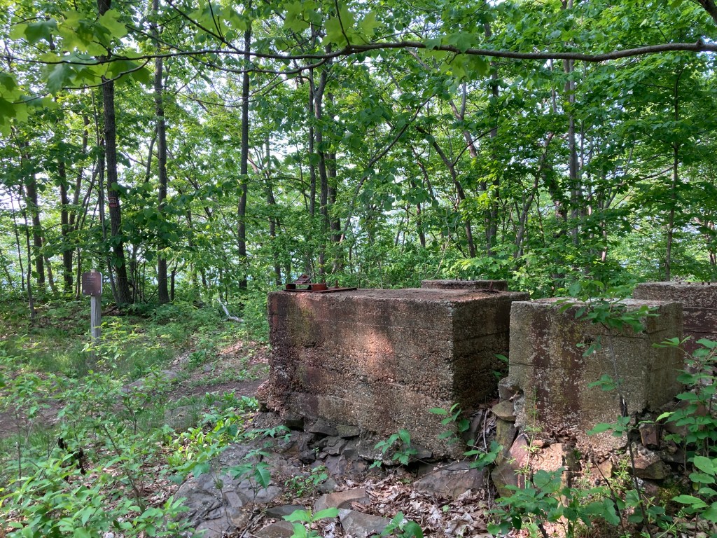
An observation tower once stood on the summit of Mount Hitchcock, providing visitors with an elevated vantage point over the Connecticut River Valley. The tower was dismantled and its concrete footings are still visible today at the peak of Hitchcock. I haven’t been able to determine the dates of its construction and removal.
Recommended ascent routes: The most convenient starting point for an ascent of Mount Hitchcock is the Notch Visitor Center on Route 116 between Amherst and South Hadley. There is a large parking area, trail maps, and seasonal visitor facilities. Most hikers will approach Hitchcock from the east by first climbing Bare Mountain, although longer and more challenging approaches are possible from Mount Holyoke to the west.
Bare Mountain and Mount Hitchcock Out-and-Back: This is probably the best option for hikers looking to reach Mount Hitchcock without committing to a full-day excursion (and it’s the route I took). From the Notch Visitor Center, cross Route 116 and follow the white-blazed New England Trail westward. The trail climbs steeply through hardwood forest and across rocky terrain to the open summit of Bare Mountain, where there are some outstanding views of the Pioneer Valley. Continue west along the ridge, descending into a saddle before climbing again toward Mount Hitchcock. There are several rocky viewpoints along the way and some interesting ledge formations. Return by the same route for a hike of 3 miles and about 900 feet of cumulative elevation gain. Although relatively short, the steep rocky sections make this a moderately strenuous hike.
Mount Hitchcock from Mount Holyoke Out-and-Back: A more ambitious approach begins at the Summit House atop Mount Holyoke, accessible by the seasonal auto road in Skinner State Park. From there, follow the New England Trail eastward along the Seven Sisters ridge. This is a surprisingly rugged section of trail, with constant ups and downs as it crosses a series of small summits and deep notches. The route offers some spectacular views north and south across the Pioneer Valley. After roughly 2.6 miles, the trail reaches Mount Hitchcock. Return by the same route. Covering some very rugged terrain, this is a challenging route of about 5.2 miles and 1,500 feet in cumulative elevation gain.
Western Holyoke Range Traverse: An ambitious and very popular point-to-point route that requires leaving a car at each end or arranging a pickup. Beginning at the Skinner State Park parking area at the foot of Mount Holyoke, walk along the road southward to the head of the New England Trail/Metacomet-Monadnock Trail. Ascend Mt. Holyoke (a beautiful climb) then proceed over the succession of rocky summits that make up the Seven Sisters. Follow the ridgeline to Mount Hitchcock and then Bare Mountain. Descend to the Notch Visitors Center. The route is approximately 5.5 miles one way, with about 1,650 feet of cumulative climbing. This is one of the classic ridge hikes in western Massachusetts and a great way to experience the dramatic landscape of the Holyoke Range.
Enjoy the trail!


Leave a Reply