Elevation: 1,201 feet
Prominence: 965 feet
Isolation: 7.93 miles
Summit coordinates: 42°14’30.1″N 72°38’53.7″W
Town: Holyoke, Massachusetts
Conservation Area: Mount Tom State Reservation
Links:
Mount Tom on Peakbagger
Mount Tom on ListsofJohn
Mount Tom on AllTrails
Mount Tom State Reservation website (including trail map)
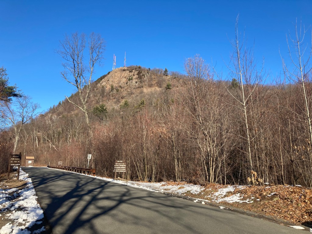
General info: Mount Tom, at 1,201 feet (366 m), is one of the most striking peaks in the Connecticut River Valley of western Massachusetts. It stands on the west bank of the Connecticut River about 5 miles northwest of downtown Holyoke. Mount Tom is the southernmost and highest peak of the Mount Tom Range, a narrow ridge that runs through Holyoke and Easthampton. Geologically, it is composed of Jurassic-period traprock (basalt) formed about 200 million years ago during the rifting of Pangaea. The basalt ledges weather to a rusty-red color and form a continuous line of cliffs and talus slopes visible for miles around.
Despite its modest elevation, Mount Tom is a hub for outdoor recreation and nature observation. Most of the mountain is protected within the 2,000-acre Mount Tom State Reservation, which features over 20 miles of trails, multiple scenic overlooks, and picnic areas. The mountain’s diverse habitats several rare plant and animal communities.
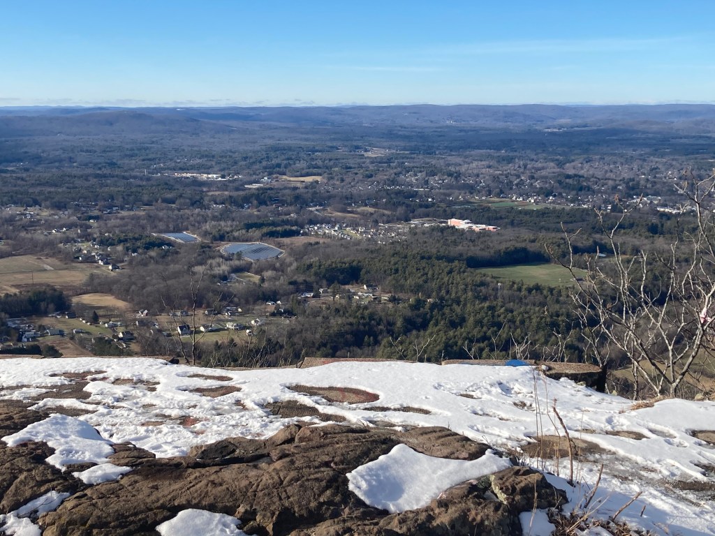
Mount Tom’s summit itself is crowned by several large communication antennas serving the Springfield–Holyoke area. While this infrastructure (and a chain-link fence around some equipment) gives the summit a somewhat industrial feel, hikers can still reach the true high point and enjoy expansive vistas. Looking west, one can see the Berkshire Highlands, and on a clear day even the distant Green Mountains. A network of well-marked trails makes it possible to explore the mountain’s peaks, woods, and historic sites on foot. Notably, the 110-mile Metacomet-Monadnock Trail – now part of the New England National Scenic Trail – runs along Mount Tom’s ridgecrest, traversing the main summit and connecting to adjacent ranges.
Historical background: Standing like a pillar in the midst of a heavily populated area, Mount Tom has had a long history of human activity, so this section will be longer than most. For thousands of years before European colonization, the Mount Tom area was part of the homelands of Native peoples, especially the Pocumtuck, who farmed the fertile valley and used the surrounding uplands seasonally for hunting and travel. The mountain’s colonial name dates from the 1660s: according to tradition, English surveyor Rowland Thomas named Mount Tom after himself, while his colleague Elizur Holyoke gave his name to Mount Holyoke across the river. English settlement brought conflict, including conflict in the area during King Philip’s War (1675–76). By the early 1800s, the lowlands had been cleared for farming, and although Mount Tom’s steep slopes were logged for timber and charcoal, they remained largely undeveloped compared to the valley below.
In the mid-19th century, New England’s mountain tourism era began, and Mount Tom’s lofty vistas drew attention. Inspired by the success of a hotel on Mount Holyoke (New England’s famed Prospect House), entrepreneurs developed resorts on the Mount Tom Range. In 1861, William Street opened the Eyrie House on Mount Nonotuck (the range’s north peak), which offered spectacular views and elegant lodging. Not to be outdone, a summit hotel was built on Mount Tom’s highest point in 1897. The Mount Tom Summit House featured an electric tramway up the mountainside. Unfortunately, these mountaintop hotels had short lives. The Eyrie House burned down in 1901 in a notorious fire (ignited when the owner tried to cremate two dead horses), leaving only stone ruins that hikers can still see today. The Mount Tom Summit House also met a fiery end: it burned in 1900 after just three years of operation, was rebuilt, and then burned down again in 1929.
In 1902 the Mount Tom summit property became the first parcel of the new Mount Tom State Reservation. This marked one of Massachusetts’ earliest moves to conserve a scenic natural landmark for public enjoyment. In the 1930s, the Civilian Conservation Corps (CCC) improved the reservation by constructing park roads, picnic shelters, and trails – some of which are still in use today. Around the same time, the mountain’s lower slopes became a center of recreation. In 1897, the Holyoke Street Railway Company opened Mountain Park at the eastern foot of Mount Tom featuring amusement rides, a dance hall, and other attractions. Mountain Park operated until 1988, when competition from larger theme parks led to its closure. The park grounds later saw new life as an outdoor concert venue, and remnants of old attractions can still be found in the woods.
On July 9, 1946, Mount Tom was the site of a tragic aviation accident. A U.S. Army Air Corps B-17 bomber (converted for transport) crashed into the mountain’s south slope during a stormy night, killing all 25 service members on board. It was the deadliest air crash in New England up to that time. Today, a memorial plaque along the New England Trail (near the crash site) commemorates the lives lost. Hikers in the area can still find scattered fragments of the plane in the woods as a somber reminder of the event.
A small ski area opened on the mountain’s northeast side in 1962. Mount Tom Ski Area featured several chairlifts and trails, and for decades it was a popular ski resort for regional residents. The ski area ultimately closed in 1998 due to economic difficulties. Its lodge and lifts were removed and the state and other groups worked to purchase the ski area land to fold it into the state reservation, preventing development that might have marred the mountain’s eastern face. This effort succeeded in the early 2000s, ensuring that the entire ridgeline remains protected open space.
Recommended ascent routes: There are many different ways to approach Mount Tom. Here are just a few:
South and East side to Railway Path: A fairly quick and easy route to the summit begins at a parking area on Route 141. Trailheads on the east side of 141 will take you to multiple trails. One is the New England Trail, which cuts right up the steep southern face of the mountain, offering a vigorous and fast route to the top. A more gradual route follows an unnamed path around the east side of the mountain, eventually meeting up with the old Funicular Railway path (now a paved access road). This will bring you to the summit. It also passes the B-17 memorial which is along the Railway route. Double-back for a fairly easy, family-friendly route of 2.8 miles and 686 feet of elevation gain.
New England Trail from the North: A more challenging but still direct out-and-back hike runs from the main Reservation parking area at the Upper Pavilion where Reservation Road and Christopher Clark Road meet. Here you can access the New England Trail heading south to the summit, a direct shot right up the ridgeline. Follow the same route back for a hike of 3.8 miles and 932 feet in elevation gain.
Loop from Mountain Park: A longer route looping around Mount Tom and encompassing a large part of the southern end of the Mount Tom Range begins at Mountain Park at the end of Mountain Park Road. From the park, head north until you link up with the Middle Loop Trail, then to the Quarry Trail. The latter will loop all the way around to the north side of the mountain. From here, follow the New England Trail all the way up the ridge to the summit. Then follow the Railway road down and back. This challenging route is 9.3 miles and 1,621 feet in elevation gain.
There are many other places to explore in the Mount Tom Reservation but the northern part of the range will be covered on the Mount Nonotuck page.

Leave a comment