
Mass 50 Highest Public Peaks elevation rank: #38
Elevation: 1,898 feet
Prominence: 212 feet
Isolation: 1.1 miles
Summit coordinates: 42° 8′ 34” N, 73° 29′ 16” W
Town: Mount Washington, Massachusetts
Conservation Area: Mount Washington State Forest (MA) and Taconic State Park (NY)
Links:
Prospect Hill on Peakbagger
Prospect Hill on Lists of John
Mount Washington State Forest website, with trail map
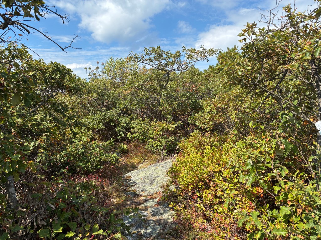
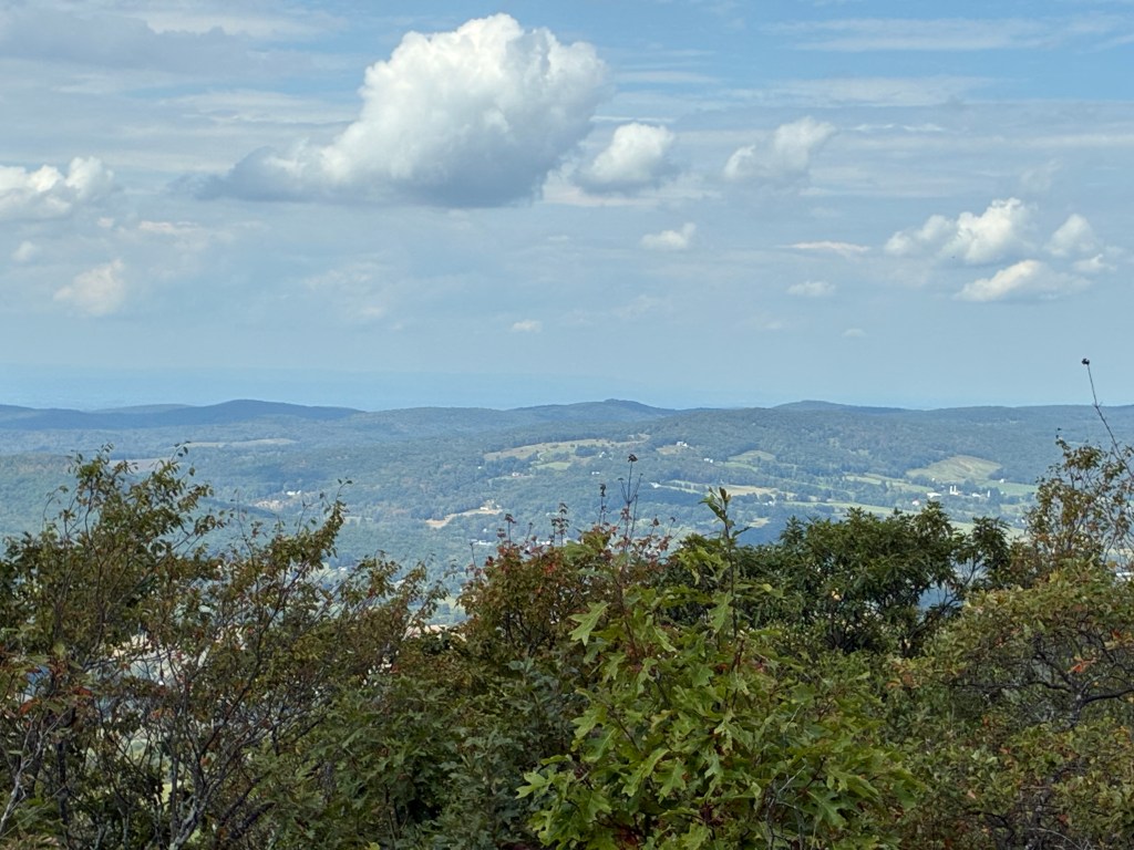
General information: Prospect Hill is a lesser-known peak perched on the South Taconic Range at the extreme southwest corner of Massachusetts, where the ridgeline forms the state border with New York. The summit straddles the MA–NY line and is marked by a historic boundary pole dated 1898, set in cement just off the trail, near a rock ledge right on the path that appears to be the true high point. The terrain along the slopes of Prospect Hill is very densely forested and so I was not expecting to find a fine vista at the top where the forest gave way to low, scrubby oak. Known as the Hillsdale Lookout, this view allows a view westward across Columbia County to the distant Catskill Mountains (including peaks like Black Dome). If approaching from the south, keep going just a bit after the MA/NY border marker and you find the Hillsdale Lookout (don’t turn around to soon or you’ll miss it!). The landscape in general here feels wild and secluded. The South Taconic Trail along this ridge is lightly traveled and quite narrow. Prospect Hill’s relative obscurity means you may have the summit to yourself, despite being located in a popular state forest region.
Historical Background: The Taconic region around Prospect Hill was originally part of the homeland of the Mohican people. While specific Native American sites on Prospect Hill aren’t well-documented, local lore holds that nearby Bash-Bish Falls (now a popular hiking site south of Prospect Hill) was a revered place. By the mid 18th century, European settlers began encroaching on this area. Notably, this region became a flashpoint of border disputes between New York and Massachusetts. The western slopes of Prospect Hill were part of the vast Livingston Manor (a New York land grant), while Massachusetts settlers claimed the plateau on the ridge. In the mid-18th century, feuds known as the “Taconic War” or “Border War” erupted, as tenant farmers in the Taconic hills defied the Livingstons and aligned with Massachusetts to gain clear title to their land. These disputes were eventually resolved through a treaty between the two states in 1786.
During the 1800s, the Taconic region underwent significant deforestation and industrial activity, especially in the valleys flanking Prospect Hill. The iron ore deposits in adjacent New York gave rise to local iron works and timber from Mount Washington’s forests was relentlessly harvested to produce fuel for those furnaces. As the local iron industry waned in the late 19th century, the South Taconics reverted to wilderness. One farm persisted on the east side of Prospect Hill known at “Summit Farm” on West Street which hosted travelers in the 19th century, in an era when mountaintop hotels in the Berkshires were popular. In the 20th century, conservation efforts took hold. Massachusetts began acquiring land on Mount Washington starting in the 1950s. Mount Washington State Forest was officially established in 1958, eventually protecting over 4,600 acres of this upland (including Prospect Hill and its surroundings). There are no known structures or fire towers that ever stood on Prospect Hill – it has always been a relatively wild summit.
Recommended Ascent Routes: There are two primary ways to approach the summit of Prospect Hill, one quite short and easy, the other longer and steeper. I had originally planned to take the longer route but as things happened, I was trying to fit multiple hikes into one day and therefore chose the shorter route for efficiency. Someday I’d like to come back and try the longer route over Mount Fray.
Approach from the south (the short route): West Street (a seasonal dirt road) will take you up to the ridgeline and the NY border. Just over the border (the road becomes Sunset Rock Road in NY) there is a small parking area where the South Taconic Trail crosses the road. From here along the South Taconic Trail it’s just 0.4 miles and about 245 feet of elevation gain to the summit of Prospect Hill. A quick and easy way to reach this peak, though it did feel a little bit like cheating.
Approach from the north (the long way): I had planned to start from the Catamount Ski Area in Egremont. The South Taconic Trail’s northern terminus is at a unmarked trailhead on MA Route 23 right at the state line, just east of the entrance to the ski area. Apparently, there is a small gravel parking area there. Another parking alternative would be to park at the ski area itself (which is typically allowed during the warm seasons…though I would call or check their website to find out for certain). The South Taconic Trail follows some very steep terrain up Mount Fray (sometimes called Catamount due to the ski area). The trail does not cross the actual summit of Mount Fray. That is apparently a tough bushwhack east of the trail. The exact highpoint is up for debate but it appears to be just over the line of the state forest on private property. (All these factors prevent Mount Fray from being on the MA 50 Highest Public Peaks list). From Mount Fray, it’s about 1.4 miles along the ridge to Prospect Hill. All told, this route would be about 6 miles and 1,500 feet in elevation gain with great views from the ski area trails.
Nearby Massachusetts 50 Highest Peaks: This area of the Taconics is rich with interesting summits—several of them on the MA 50 Highest list. Mount Everett (2,602′) is the highest summit in the South Taconics, located about 3.5 miles east of Prospect Hill. Alander Mountain (2,240′) is directly to the southwest of Prospect Hill on the NY line, and features a broad open summit. Mount Frissell (2,452′) straddles the CT–MA line to the south. Mount Race (2,370′), a dramatic ridgeline peak, is about 5 miles southeast of Prospect Hill.


Leave a comment