
Highest Point in Essex County, MA
Elevation: 420 feet (128 m)
Prominence: 337 feet
Isolation: 14.18 miles
Summit coordinates: 42°38’27.1″N 71°06’23.2″W
Town: Andover, Massachusetts
Conservation Area: Charles W. Ward Reservation (The Trustees of Reservations)
General info: Holt Hill, at 420 feet, is the highest point in Essex County, Massachusetts. It crowns the Charles W. Ward Reservation – a 700+ acre conservation property of rolling woodlands, wetlands, and meadows managed by The Trustees of Reservations. From Holt Hill’s open summit, visitors can enjoy broad vista that takes in the Boston skyline to the south (about 25 miles away) and the Blue Hills on clear days. The summit is marked by the “Solstice Stones,” a ring of granite monuments that double as seats and align with cosmic events (explained below). This hilltop meadow offers an inviting spot to relax, picnic, and take in the views. The Ward Reservation as a whole features nearly 15 miles of trails ranging from easy strolls to moderate hikes, including a boardwalk across a quaking bog (Pine Hole Pond) and paths to other scenic hilltops. Easily accessible and well-maintained, Holt Hill has become a popular destination for hikers, nature lovers, and families – a convenient “green oasis” north of Boston.
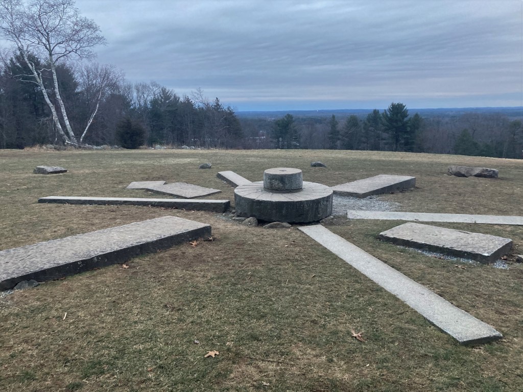
Historical background: On June 17, 1775, townspeople from Andover climbed Holt Hill to watch the distant glow of Charlestown burning after the Battle of Bunker Hill. The hill itself was named for Nicholas Holt, an early settler of Andover in the mid-17th century who established a farm here. His family worked the land for generations into the late 1800s. In 1917 the property was acquired by Charles W. Ward, and his widow Mabel Ward donated Holt Hill and surrounding acres to The Trustees of Reservations in 1940 as a memorial to her husband. As part of their legacy, the Wards had the now-famous Solstice Stones installed at the summit of Holt Hill. These granite blocks (added in the 1930s) are arranged in a large ring: the largest mark the cardinal compass points, and additional stones align with the exact spots on the horizon where the sun rises and sets on the summer and winter solstices.
Throughout the 20th century, the reservation grew as a protected landscape while also hosting some unusual endeavors. In 1957, an experimental radar tower was built on nearby Boston Hill (just north of Holt Hill) by MIT’s Lincoln Laboratory to help radar systems resist jamming and decoys released by hostile aircraft, strengthening U.S. air defense operations. The massive, rusted and decaying dishes and radar tower still stand and look like something out of a retro-futuristic Sci-Fi movie. The grassy slope of Boston Hill was also home to a small ski area that operated from the 1940s until the 1980s. The Ward Reservation was gradually expanded and, by 2013, the Boston Hill tract and other parcels were permanently protected, ensuring the entire area remains open space.
Recommended ascent routes:
Yellow Trail Loop: The easiest and most direct route to Holt Hill’s summit is via the yellow-blazed loop trail starting at the main parking area on Prospect Road. This loop of about 1 mile leads you first along a woodland path to a boardwalk over Pine Hole Pond – an interesting floating kettle bog – then climbs gradually to Holt Hill’s summit meadow. After taking in the Solstice Stones and views, the trail continues down and loops back to the parking lot. It’s a short, family-friendly hike with a nice payoff in scenery.
Boston Hill and Holt Hill via the Red Trail (Old Prospect Road), to Blue Trail (Vetter Trail/Elephant Rock Trail) to Sanborn Trail: This 4-mile loop, with about 525 feet of elevation gain, was the route I followed on my visit. Old Prospect Road makes a pleasant start, a good example of an old rural way now bypassed by modern roads. From there, the Blue Loop leads to Boston Hill, where you can enjoy the view, visit Elephant Rock, and see the old radar station (very eerie). I then followed a short section of the Red Loop to connect with the Sanborn Trail, which curves around to the north slope of Holt Hill. This steeper side of Holt Hill rises out of the marshes of Cat Swamp, and while Holt Hill isn’t large, the unmarked path up this slope gives you a workout. Unlike the gentler Yellow Trail, it feels like you’ve climbed something. Altogether, it makes for an interesting and varied walk.

Leave a comment