Highest Point in Franlkin County, MA
Elevation: 2,838 feet
Prominence: 338 feet
Isolation: 2.71 miles
Summit coordinates: 42°42’54.7″N 73°01’24.2″W
Town: Monroe, Massachusetts
Conservation Area: Private property
Links:
Crum Hill on Peakbagger
Crum Hill on Listsof John
General info: Crum Hill, at 2,838 feet, is the highest point in Franklin County, Massachusetts. It straddles the towns of Monroe and Florida, lying in the Hoosac Range (the northwestern edge of the broader Berkshire Mountains). The main summit is in Monroe. Geologically, Crum Hill is actually the highest point of the Berkshire Mountains, even though the taller Mount Greylock (3,491 ft) in nearby Berkshire County is often mistaken as such (Greylock belongs to the separate Taconic Range). Crum is the highest Massachusetts summit outside of the conglomerate of peaks known as the Greylock Massif .
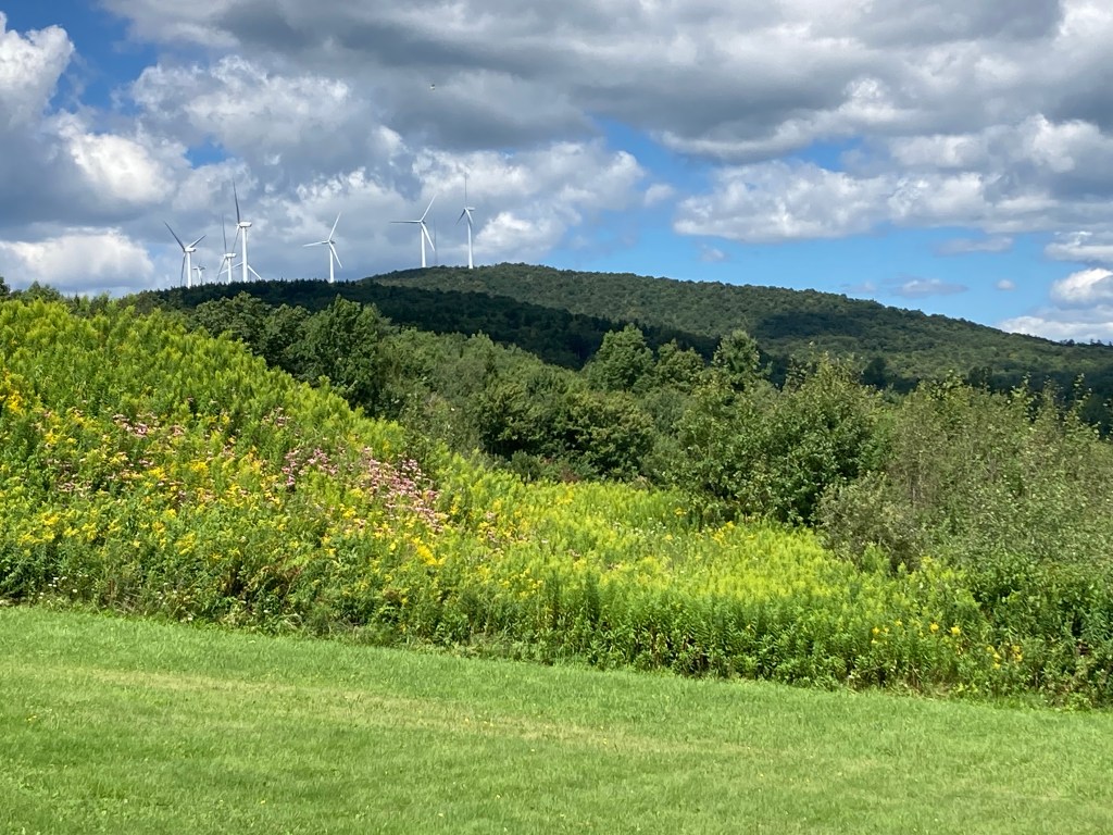
Crum Hill is private property. An active wind farm is located on its summit. Obtaining permission to hike the existing trails (of which there are few) might be possible by contacting landowners, however access to the summit is pretty much off limits due to the wind farm (the Hoosac Wind Power Project). It never hurts to ask, though. I’d suggest contacting local authorities in Monroe or Florida first.
The lower slopes of Crum Hill on the north and east sides lie within Monroe State Forest (public conservation land). Hiking is permitted via the established paths. Monroe State Forest is a beautiful but remote conservation area, well worth hiking but be aware that there are few blazes and very little signage. Neighboring Spruce Mountain in Monroe State Forest is a great hike and, east of that, the Raycroft Overlook is a beautiful spot to linger.
Historical background: Prior to European colonization, the uplands surrounding Crum Hill were part of a broader cultural landscape shared by the Pocumtuck and Mohican peoples. While the steep terrain and harsh winters made permanent settlement unlikely, Native groups likely used the area seasonally for hunting, fishing, and foraging. The nearby Deerfield River served as a vital travel corridor, and tributaries like Dunbar Brook may have hosted temporary camps. Today, physical evidence of Indigenous activity is sparse in this specific highland zone.
European-American settlement came relatively late. The town of Monroe, incorporated in 1822, saw limited development due to its elevation and isolation. Much of the land around Crum Hill was cleared for 19th-century subsistence farming and sheep grazing, and remnants of this era—stone walls, cellar holes—can still be found in the woods. Logging became a major activity by the late 1800s, especially after a rail line was built through Monroe to support the pulp industry. The nearby James Ramage Paper Company mill, established in 1887, relied heavily on timber harvested from the region’s hillsides, likely including Crum Hill’s slopes.
As hill farms declined in the early 20th century, forest began to reclaim the land. The creation of Monroe State Forest in 1924 marked a turning point, as Massachusetts began conserving the area’s recovering woodlands. In the 1930s, the Civilian Conservation Corps (CCC) conducted reforestation work. While the summit of Crum Hill itself was never included in the state forest, its flanks and surrounding landscape benefited from these conservation efforts.
The most dramatic change came in the 21st century, when Crum Hill’s summit was selected for a commercial wind farm. Due to its high elevation and constant wind exposure, it became the site of the Hoosac Wind Power Project, completed in 2012. The summit was cleared and leveled to install nine wind turbines, each towering over 300 feet tall. This development brought local revenue but also altered the summit’s natural character and introduced restrictions on public access.
Recommended ascent routes: I can’t recommend any route to the summit as it’s private property, but I can recommend a hiking route through the Monroe State Forest area on Crum Hill’s eastern slopes. Begin at the Monroe State Forest parking area, located at the junction of Main Road and Raycroft Road in Monroe, Massachusetts. From the parking area, walk about 0.3 miles down Raycroft Road (an unpaved extension) to reach the Spruce Mountain Trail, marked with blue blazes on the right-hand side. Keep an eye out, it’s easy to miss. This official state forest trail climbs steadily through mixed hardwood forest, winding its way up the slope of Spruce Mountain. While the trail is marked, it is not heavily traveled and can be faint in spots, so keep your map or GPS device handy. About 1.5 miles from the parking area, the trail intersects with a snowmobile trail that runs east–west across the ridge. At this junction, turn west (right) onto the snowmobile trail, which contours along the eastern slope of Crum Hill. This wide track, maintained by the Florida Mountaineers snowmobile club, offers an efficient route toward Crum Hill. It does not lead directly to the summit, but fairly near it on public land. Again, I do not recommend hiking to the summit without permission.

Leave a comment