Mass 50 Public Peaks elevation rank: #50
Elevation: 1,593 feet
Prominence: 580 feet
Isolation: 3.86 miles
Summit coordinates: 42°36’24.8″N 72°42’59.3″W
Town: Shelburne, Massachusetts
Conservation Area: Shelburne State Forest
Links:
Massaemett Mountain on Peakbagger
Massaemett Mountain on Listsof John
Massaemett Mountain on AllTrails
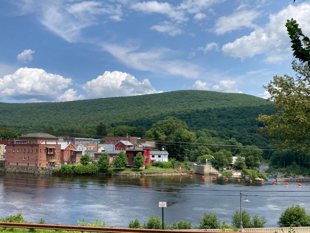
General info: One of my very favorites on this list, Massaemett Mountain rises just east of Shelburne Falls and the Deerfield River. Though modest in elevation at 1,594 feet, it’s a prominent and locally beloved peak. The mountain was formerly known as Bald Mountain (and is still labeled as such on some maps), although its slopes are now densely wooded and part of a protected patchwork of conservation land. The northern side lies within Mass Audubon’s High Ledges Wildlife Sanctuary, while the summit area (49 acres) is owned by the Commonwealth as part of Shelburne State Forest. Public trails are maintained through a collaboration between the Town of Shelburne, Mass Audubon, and volunteer groups.
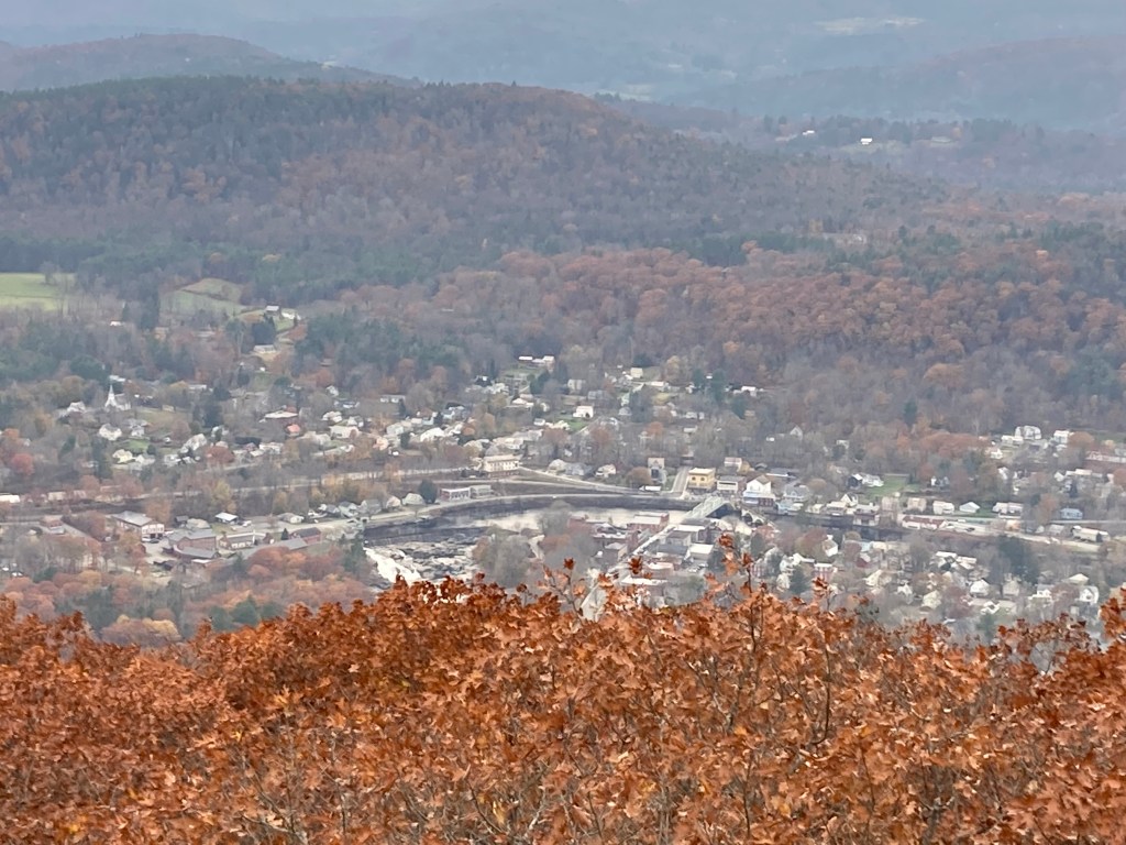
Although it’s the smallest peak on the Massachusetts 50 Highest Public Peaks list, Massaemett offers a surprisingly vigorous hike, especially when approached via the steep trail from the west. The climb gains nearly 1,000 feet in a short distance, and the summit rewards the effort with some of the best views in the region. Atop the mountain stands a historic 60-foot stone fire tower, built in 1909 (see historical background below for more on this). The top cab is kept locked, but hikers can ascend the internal stairway and look out through windows in four directions. Views extend west to the Berkshires and Mount Greylock, north to the Green Mountains of Vermont, east to Mount Monadnock in New Hampshire, and south to the Holyoke Range beyond the Connecticut River Valley. The view down to the village of Shelburne Falls is particularly lovely. Along the northern shoulder of Massaemett lies the High Ledges Sanctuary—open ledges with expansive views and a peaceful feel.
Historical background: Massaemett Mountain holds historical significance in the context of Indigenous travel routes. The Mohawk Trail – originally a Native American footpath used for thousands of years – runs along the base of Massaemett. This ancient route connected the Connecticut River valley to the Hudson River valley, and later became the first scenic highway in New England (today’s Route 2). At the foot of the mountain, the Deerfield River cascades over Salmon Falls (now known as Shelburne Falls), which was an important fishing site for Native peoples including the Pocumtuck, Mahican, and Mohawk tribes. The name “Massaemett” honors a Native leader: Chief Massaemett was a 17th-century Pocumtuck sachem in this region.
In more recent history, Massaemett’s summit became known for its observation tower. During the late 1800s, local residents built wooden lookout towers on the summit for recreation and scenery – however, one tower burned down and the next was toppled in the great Portland Gale of 1898. Determined to create a more permanent structure, a group of Shelburne Falls citizens raised money for the current stone tower in 1909. It is built from rock quarried from the mountaintop. By 1911, the state’s Fire Warden Department began using the round tower as an official fire lookout. The Shelburne Fire Tower has since been staffed during periods of high fire danger and remains one of only two active stone fire towers in New England. Today the tower is owned by the Commonwealth of Massachusetts and carries the designation Fire Tower #40.
High Ledges Sanctuary also has a human history: in the mid-1900s, Professor Ellsworth Barnard, a leading 20th century naturalist and conservationist in the region, built a cabin on that north-side ledge and later donated the land to Mass Audubon in the 1970s. The cabin burned down in 1970, but the foundation and stone chimney still stand at the overlook as a quiet historical reminder.
Recommended ascent routes: The primary hiking route up Massaemett is the Fire Tower Trail, which approaches from the west (Shelburne Falls side). This trail begins near the junction of Route 2 and Halligan Avenue, at a signed trailhead by a culvert just east of the village. The path climbs roughly 1.25 miles to the summit, gaining about 1,000 feet of elevation in a short distance. Hikers should expect a strenuous ascent.
An alternate and highly scenic route is via the Ridge Trail from the north, through High Ledges Wildlife Sanctuary. This approach is a bit longer but more gradual. Hikers can start at the Mass Audubon sanctuary parking (Patten Road in Shelburne) and follow the clearly marked Sanctuary Trail about 1 mile to the famed High Ledges overlook. The sanctuary trail meanders through wildflower meadows and forests (especially beautiful in spring bloom) and passes the stone chimney ruins of the old Barnard cabin before ending at The Ledges, a broad outcrop with a stunning view of Shelburne Falls and the Deerfield Valley below. From this overlook one can continue southward along the white-blazed Ridge Trail into the woods toward the summit. The Ridge Trail runs roughly 1 mile, crossing a privately owned working farm on the mountain’s north ridge (please stay on the path which is a public right-of-way). The grade is moderate and wooded. It eventually meets the Fire Tower at the summit. In total, hiking from the Audubon lot to the summit via High Ledges is about 2.2 miles one-way and involves about 900 feet of elevation gain.
Nearby Listed Peaks: There are no Mass 50 Highest Public Peaks in hiking distance of Massaemett but there are several just a short drive away. To the east is Mount Grace, situated in Warwick, and the highest peak in the North Quabbin region, ranking #49 on the list. The summit is topped by an open steel fire tower that delivers one of the best 360-degree views in central Massachusetts.
To the west just a short drive away is a cluster of three listed peaks. Negus Mountain, located in Rowe and Charlemont, ranks #45 on the list. It offers a rugged and rewarding hike with steep ledges and panoramic views into the Deerfield River Gorge and the surrounding ridgelines. Todd Mountain, along the Charlemont–Florida town line in the Mohawk Trail State Forest and is one of the more underappreciated peaks on the list. Clark Mountain, adjacent to Todd Mountain, also lies within the Mohawk Trail State Forest.
Click photos to enlarge:


Leave a comment