
Mass 50 Public Peaks rank: #44
Elevation: 1,793 feet
Prominence: 413 feet
Isolation: 4.4 miles
Summit coordinates: 42°15’18.8″N 72°59’11.8″W
Town: Chester, Massachusetts
Conservation Area: Private property but public access allowed on trails, conservation easement held by Hilltown Land Trust, adjacent to Chester-Blandford State Forest
Links:
Round Top Hill on Peakbagger
Round Top Hill on Listsof John
Round Top Hill on AllTrails
Round Top Hill on Hilltown Land Trust (including trail map)
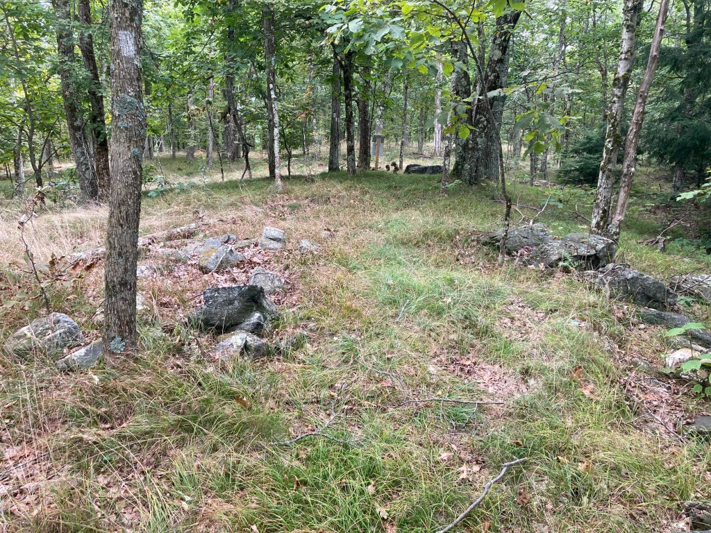
General info: Round Top Hill is a prominent peak in the southern Berkshires. It is the highest point in Hampden County and the town of Chester. Despite its modest elevation, the hill has some steep terrain and interesting trails. The summit itself features a small grassy clearing dotted with scrub oak and shagbark hickory trees, creating a unique high-elevation habitat uncommon in this region. A USGS triangulation marker and a summit register can be found at the top. Overall, Round Top Hill is a quiet, lesser-known hike. Importantly for hikers, Round Top Hill is part of a larger network of protected lands. The mountain’s west flank abuts Chester-Blandford State Forest, and much of the summit area was permanently protected in 2015 through a land donation to the Hilltown Land Trust. A section of the long-distance Unkamit’s Path (white-blazed) traverses the ridge and summit, linking Round Top to other hills in the region. Unkamit’s Path is named after a Native American guide who led settlers through the Westfield River valley in colonial times, a nod to the region’s early history. The combination of state forest and land trust stewardship means the mountain’s natural character is well-preserved, and public access is welcomed as long as hikers stay on the marked trails. Despite being in a rural area, the trailheads are only a few minutes’ drive from Route 20 and the village of Chester, making this peak relatively accessible yet still quite remote and peaceful.
Historical background: The name “Round Top” is straightforward—early New Englanders often named hills based on appearance, and this mountain’s gently rounded summit profile likely inspired its moniker. There’s no evidence of a specific Indigenous name for Round Top Hill, but the area was historically part of the homelands of the Algonquian-speaking peoples of the Berkshires, including the Mahican and Pocumtuck. The Westfield River valley just north of the mountain served as a travel corridor for Native Americans and, later, for colonists. This history is reflected in the naming of Unkamit’s Path, which crosses the mountain and honors a Native guide.
In the 19th century, Chester and the surrounding area—including Round Top’s slopes—gained fame for emery mining. Emery, an abrasive rock composed of corundum and magnetite, was first discovered here in 1864. A rich emery-bearing vein ran through the hills for several miles, and by the late 1800s Chester had six emery mines and four grinding mills processing the mineral. One major mine, known as the “Old Mine,” operated on the side of Round Top into the early 1900s. During the Civil War era and beyond, Chester’s emery was prized for polishing metal—especially at the Springfield Armory. The industry declined after World War II when cheaper and synthetic abrasives became available. Today, hikers may still spot prospect pits or tailings hidden among the trees—quiet traces of the mountain’s industrial past.
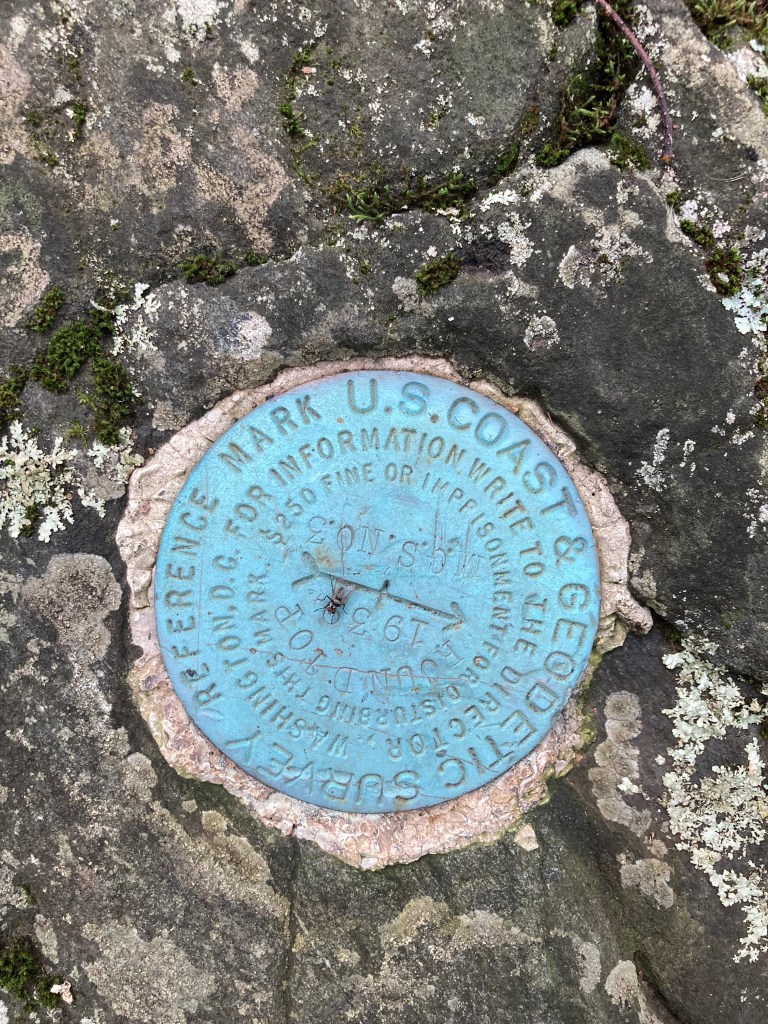
Like most New England peaks, Round Top was likely logged extensively in earlier times. The old fire road (now the orange trail) and scattered stone walls suggest past timber harvesting and possibly rough pasture on the lower slopes. No fire tower was ever built here—other nearby summits, like Tekoa Mountain, were preferred for lookouts. Still, Round Top did play a role in early mapping and surveying. In the early 20th century, U.S. Coast & Geodetic Survey crews installed a triangulation station on the summit. A benchmark disk dated 1942 remains embedded in the bedrock, a relic of the mountain’s use as a regional survey point.
By the late 20th century, the ecological and scenic value of Round Top drew attention from conservationists. Local residents Will and Sarah Freedberg, who owned land on the mountain, worked to protect it from development. In 2015, they donated a conservation restriction on 260 acres to the Hilltown Land Trust, ensuring public access and long-term habitat protection.
Recommended ascent routes:
Round Top Hill can be reached via two short but distinct trails from Round Hill Road in Chester. The closest parking available is the Hilltown Trust parking area at Knox Acres on Round Hill Road. Parking here, you’ll have to walk up Round Hill Road a ways to get to the trailheads. It did not appear to me as though there was room to park at the trailheads, but I imagine some do manage it.
- Unkamit’s Path (White Trail): This is the steeper option—just 0.4 miles to the summit, but with a sharp climb over rocky ledges and mossy boulders. A carved oak tree marks the trailhead. It’s a quick, satisfying ascent with a bit of a workout.
- Fire Road Trail (Orange Trail): A gentler 0.5-mile route that follows an old woods road through hardwood forest. There’s one steeper section near the middle, but overall it offers a more gradual and steady climb.
Round Top Hill Loop: Most hikers combine both trails into a loop for a short but varied hike. The link will take you to my route. I went up the Fire Road Trail (Orange) and down Unkamit’s Path (white) for a 1.75 mile hike (if you include the walk from the parking area to the trailhead) and 475 of elevation gain. Many websites claim there are expansive views from the summit–in fact, there are none. But the meadow at the summit is quite pretty and a pleasant place to linger.
Nearby Listed Peaks: Round Top Hill is one of only two Hampden County peaks on the “Massachusetts 50 Highest Public Peaks” list – the other being its neighbor Gobble Mountain in Chester. Gobble Mountain (#47) lies about 2 miles north of Round Top and is connected by the continuation of Unkamit’s Path. These two would make a good duo for a longer hike. Roughly a half hour drive to the west will take you to Hunger Mountain (#43).
Click photos to enlarge:

Leave a comment