Mass Public Peaks elevation rank: #41
Elevation: 1,843 feet
Prominence: 171 feet
Isolation: 3.31 miles
Summit coordinates: 42°31’48.7″N 72°49’11.5″W
Town: Ashfield, Massachusetts
Conservation Area: “Peter Hill Trail,” Town of Ashfield right of way, also adjacent Bear Swamp Preserve
Links:
Peter Hill on Peakbagger
Peter Hill on ListsofJohn
Peter Hill on Alltrails
Bear Swamp Preserve, Trustees of Reservations website, including trail map
General info: I’ll admit, I’ve sort of “smuggled” Peter Hill onto this list. It doesn’t meet the prominence criterion, and of all the peaks listed here, it probably feels the least “mountainous.” While there are steep slopes on its east and west sides, the approach from the north—the route I recommend—is quite gradual and doesn’t feel much like a climb. Near the summit, the Peter Hill Trail runs alongside the expansive yard of a large private home, and the summit itself is densely wooded with no views to speak of. I know, I’m really selling it, right? But here’s why it’s worth including: Peter Hill is among the higher elevations in the Berkshires (and the highest point in the town of Ashfield), it has a well-maintained trail leading directly to its summit, and my recommended approach passes through the Bear Swamp Preserve, which offers some truly lovely hiking on excellent trails. It’s definitely worth a morning or afternoon outing.
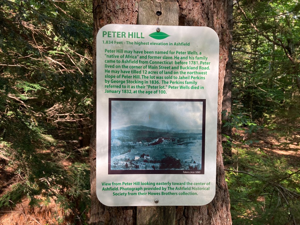
Historical background: The Town of Ashfield has placed a small sign at the summit with some historical information (a rare thing–I rather wish more conservation areas did this). According to the sign, the hill is likely named for Peter Wells, a formerly enslaved person who brought his family to Ashfield from Connecticut before 1781. It is believed he owned land on the northwest slope of the hill. Later owners referred to that land as the “Peter lot” and the name eventually was applied to the whole hill. Approaching Peter Hill through rocky Bear Swamp, with its many running streams, it’s hard to believe that anyone could farm here. But as the Trustee’s website says, “To early settlers, Bear Swamp was truly rough terrain: steep, wooded hillsides and exposed bedrock descending to boggy wetlands, and swamp. Nonetheless, all of the land was cleared for forest products, pasture, and even hay fields. But contemporary explorers will find a landscape of hard beauty, with field reclaimed by forest and the dark lowlands illuminated by colorful wildflowers in bloom.”
The Trustees of Reservations acquired the original Bear Swamp property from Rev. Philip and Esther Steinmetz in 1968. The Steinmetzes, committed to preserving wild spaces in Ashfield, had begun purchasing land in the early 1960s and later transferred additional parcels to the Trustees. As you continue south through Bear Swamp and cross Bear Swamp Road, you’ll come to the Peter Hill Trail—a town right-of-way that crosses private land. I haven’t yet uncovered when the town secured this right-of-way, but the intent is clear: to provide public access to the summit.
Recommended ascent routes:
Bear Swamp Preserve and Peter Hill: This was my route to Peter Hill through the Bear Swamp Preserve. It was about 4.5 miles with 600 feet of elevation gain. Parking at the Bear Swamp trailhead on Hawley Road is just on the shoulder of the road but it’s a wide shoulder with plenty of room. I followed the Fern Glade Trail to the Peter Hill Trail. Walking the latter up to the summit, be careful to stay on the trail as this is a public right of way on private land. Heading back through Bear Swamp, I took the North-South Trail and Lookout Trail back. Nice scenery and several babbling brooks. Be advised that the “lookout” on the Lookout Trail has grown in, but if you cross Hawley Road opposite the trailhead, a path will take you to the Apple Valley Overlook which has a lovely view.
Nearby Mass 50 Highest Public Peaks: There are no other listed peaks within hiking distance of Peter Hill, but Massaemett Mountain in nearby Shelburne Falls is just a short drive away. The two could easily be combined into a single day trip and make a good pair. Mohawk Trail State Forest, along with its three listed peaks—Todd Mountain in Charlemont, Clark Mountain, and Negus Mountain—is also close by. However, there’s enough to explore in that area that it’s probably best saved for its own dedicated outing.

Leave a comment