Mass Public Peaks rank: #27
Elevation: 2,109 feet
Prominence: 746 ft.
Isolation: 8.25 miles
Summit coordinates: 42° 13′ 10” N, 73° 15′ 59” W
Town: Monterey, Massachusetts
Conservation Area: Beartown State Forest
Links:
Mount Wilcox on Peakbagger
Mount Wilcox on ListsofJohn
Beartown State Forest website (including trail map)
Beartown State Forest on AllTrails
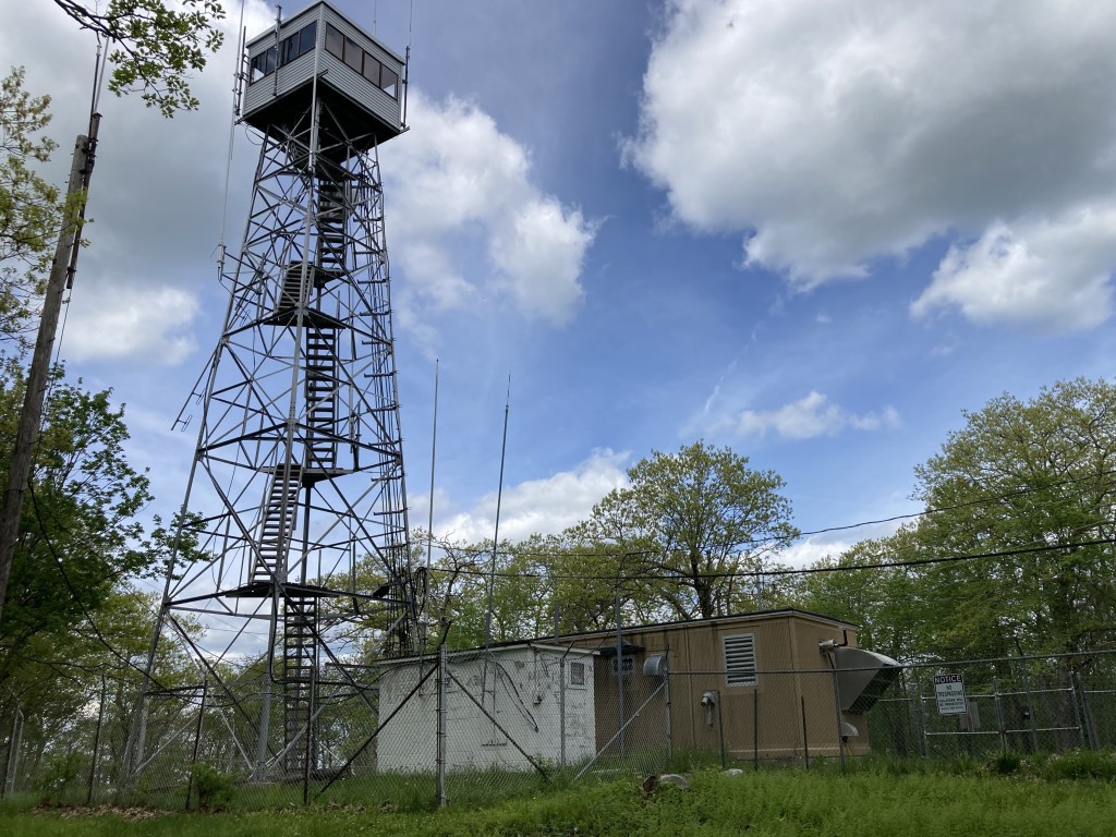
General info: Mount Wilcox, standing at 2,109 feet, is the high point of Beartown State Forest in Monterey, Massachusetts. The mountain is accessible via the Mount Wilcox Trail, which eventually connects to Mount Wilcox Road, providing access to the summit. The trail is a pleasant footpath that traverses diverse terrain, including hemlock forests and serene ponds, offering a gradual and easy ascent. At the wooded summit, you’ll find a fenced-in fire tower and a few small antennas, which may not make it the most majestic peak among the 50 Highest Public Peaks. However, Beartown State Forest is well worth exploring. Neighboring Benedict Pond Peak, also on the 50 Highest Public Peaks list, can easily be included in the same day-hike, providing an excellent opportunity to check off two peaks in one trip.
Historical background: Beartown State Forest lies within the ancestral homeland of the Mohican people, who considered nearby peaks like Monument Mountain sacred. By the early 1800s, Euro-American settlers had cleared much of the area for farms, pasture, and charcoal production, dramatically altering the wilderness. By the late 19th century, many farms were abandoned, and extensive logging stripped the hills of trees to supply lumber and charcoal for local iron furnaces.
Fred Benedict (1866–1930) owned a dairy farm encompassing Benedict Pond, which served as a valuable ice source before refrigeration. Each winter, he cut ice blocks and stored them in insulated icehouses. The pond later took on his name. In the early 1900s, the land became a private hunting preserve under Frederick Pearson, a wealthy engineer who perished in the 1915 sinking of the RMS Lusitania. It was later sold to the Commonwealth of Massachusetts for conservation.
Massachusetts began acquiring Beartown’s land in 1920–21 to establish a state forest. During the Great Depression, the Civilian Conservation Corps (CCC) developed miles of roads, trails, a campground, and sections of the Appalachian Trail (AT). One of its major projects was building an earthen dam (1934–35) to enlarge Benedict Pond, transforming it into the 35-acre lake seen today. The fire tower atop Mount Wilcox, constructed in 1934, remains a historical feature. After decades of re-growth, the once-barren slopes are now a mature second-growth forest, approximately 90–100 years old.
The origins of Mount Wilcox’s name are uncertain, but one theory connects it to Walter Dwight Wilcox (1869–1949), an early explorer of the Canadian Rockies who made first ascents of several peaks. Nearby Mount Frissell, about 16 miles southwest, may strengthen this theory, as Lewis Frissell, another notable mountaineer, accompanied Wilcox on expeditions. The link between their namesakes and proximity suggests more than coincidence.
Recommended ascent routes:
Mount Wilcox and Benedict Pond Peak in Beartown State Forest: This was my route around Benedict Pond and through Beartown State Forest to Mount Wilcox. An approach from the south is the most logical route as the main entrance and parking are situated at the southern end of the state forest by Benedict Pond. Plenty of parking. As noted, Benedict Pond is quite pleasant and I saw a good number of people fishing there. I took the Beartown Mountain Trail to the smaller Lookout Trail which ascended Benedict Pond Peak. The lookout on the shoulder of Benedict Pond Peak is really the only place along this route where you get a view, and it’s a very pleasant one looking west to the Taconics. A good place to stop for a bit. Then I took the Wildcat Trail to the top of Benedict Pond Peak (not an officially named summit) and then connected with the Mount Wilcox Trail, which I found pleasant. I knew in advance that the summit of Wilcox was hardly pristine, but it was still a bit of a disappointment. I was glad to get off the road and bushwhacked back to the Mount Wilcox Trail.
Nearby Listed Peaks: Benedict Pond Peak, as mentioned, is located a short distance from Mount Wilcox. To the east, Hunger Mountain is just a short drive away, while Peeskawso Peak lies to the west. Peeskawso Peak is particularly striking, featuring dramatic craggy rock formations and offers a fun hike. Hunger Mountain is a less dramatic to be sure, a humble peak but nonetheless has a lovely view from its summit.

Leave a comment