Mass Public Peaks rank: #9
Elevation: 2,585 ft.
Prominence: 244 ft.
Isolation: 1 mile
Summit coordinates: 42° 35′ 26” N, 73° 11′ 57” W
Town: Cheshire
Conservation Area: Mount Greylock State Reservation
Links:
Rounds Rock on Peakbagger.com
Rounds Rock on ListsofJohn
Massachusetts Mount Greylock State Reservation Website
Mount Greylock State Reservation on Alltrails
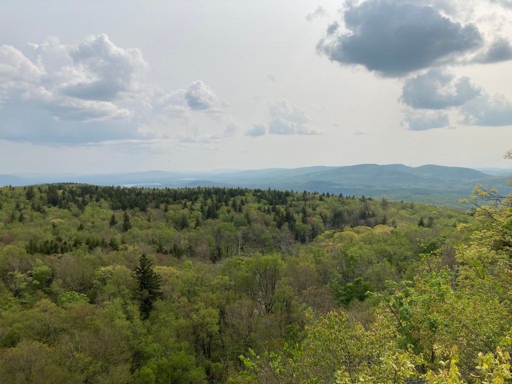
General info: Some of the information in this post overlaps with my write-up on Saddle Ball Mountain, the higher peak just north of Rounds Rock and #2 on the Massachusetts 50 Public Peaks list. Together, these two make an excellent pair for a day hike. Rounds Rock, while part of the larger Greylock Massif in the Taconic Range, is prominent enough by Massachusetts standards to be considered an independent peak. Located on the southern end of the Greylock Massif, Rounds Rock is accessible via the scenic Rounds Rock Trail. Northern hardwoods like sugar maple, yellow birch, and American beech dominate the forests. In the meadows, wildflowers like trillium, asters, and goldenrod add splashes of color, especially in spring and early autumn. The summit, a rounded high point right along the trail, is relatively unremarkable and wooded. However, if you continue southwest along the trail and take a left onto a short side trail, you’ll emerge onto Rounds Rock’s craggy cliff (don’t miss it!) where you’ll find one of the best views in the area. To the south and southwest, you can see various peaks, including Brodie Mountain, Widow White’s Peak, Jiminy Peak, and on a clear day, all the way to the Catskills in New York. It’s a perfect spot to relax, enjoy lunch, and, as I did, listen to the eerie calls of ravens echoing from the woods below.
Historical background: Rounds Rock and the surrounding area were once part of a large tract of farmland associated with Jabez Rounds, who farmed this high ground in the early 1800s; local tradition holds that he received the land in the late 18th century, possibly in recognition of his Revolutionary War service. The open uplands became known for their abundance of wild blueberries and huckleberries, which still carpet the rocky outcrops along the Rounds Rock Trail in late July. In 1914 the Commonwealth acquired the cliffs and surrounding slopes for Mount Greylock State Reservation, and an early Greylock Commission report singled out Rounds Rock for its “extensive view of all southern Berkshire” and the valley between the Hoosacs and the Taconics—one of the finest panoramas in the county. More recently, the site became linked to a 1948 plane crash: a small Cessna went down on the flank of Rounds Rock, and hikers today can still see scattered wreckage and a memorial to pilot John Newcomb just off the loop trail.
Recommended ascent routes: The Mount Greylock State Reservation covers about 12,000 acres and is full of excellent trails. A DCR trail map can be found here. I have a couple suggested routes, but there are many other possibilities.
Jones Nose Trail plus the loop to Rounds Rock –Overall about 4.6 miles and 1,300 in elevation gain. Park at the Jones Nose Trailhead Parking area (which is only open seasonally). This parking area is fairly high up on the massif, so it feel a little bit like cheating, but it’s a great way to access the summits of both Saddle Ball Mountain and Rounds Rock on a day hike. And at 1,300 feet gain, it’s still a decent climb.
Bradley Farm Trail to Northrup Trail to Woodason Spring Trail: If you want a longer hike to Rounds Rock, park at the Greylock Visitors Center on Rockwell Road, take the Bradley Farm Trail to the Northrup Trail (which will take you to Rounds Rock) then descend via the Woodason Spring Trail back to the Bradley Farm Trail. This route is about 7.2 miles with 1,100 feet of elevation gain.
Nearby Listed Peaks: The Greylock Massif consists of a number of peaks, some of them prominent enough to be considered independent. Several nearby are on the Mass Public Peaks list including Greylock itself, Mount Williams, Stony Ledge, Ragged Mountain, Mount Prospect, and Rounds Rock. As mentioned above, Saddle Ball is the closest and easily paired with Rounds Rock.
Back to Massachusetts 50 Highest Public Peaks list
Click photos to enlarge:


Leave a comment