
Mass Public Peaks rank: #13
Elevation: 2,517 ft.
Prominence: 441 ft.
Isolation: 5.2 miles
Summit coordinates: 42° 36′ 5” N, 73° 1′ 41” W
Town: Savoy
Conservation Area: Savoy Mountain State Forest
Links:
Borden Mountain on Peakbagger
Borden Mountain on ListsofJohn
Savoy Mountain State Forest Website (including trail map)
Savoy Mountain State Forest on Alltrails
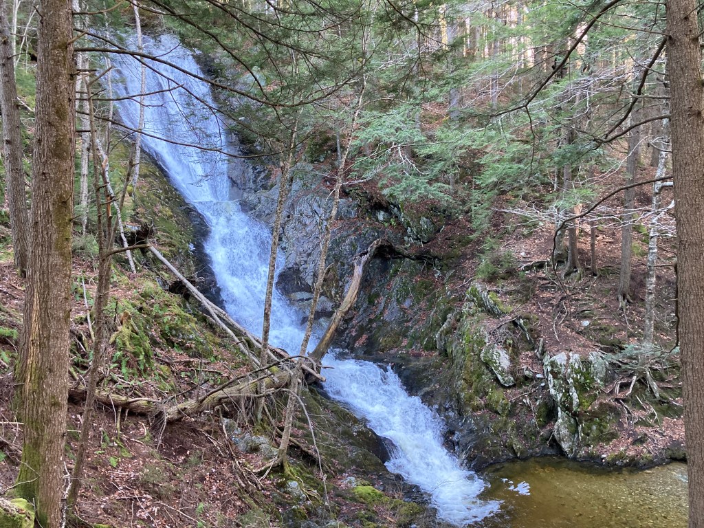
General info: The summit of Borden Mountain, located in the northern Berkshires, is wooded and has only a sliver of a view along the power line corridor. The power lines and fenced-off fire tower give the summit a somewhat utilitarian feel rather than a natural one. The easiest access is via a paved road, which further detracts from a wilderness experience. However, Borden Mountain sits within the expansive 11,000-acre Savoy Mountain State Forest, which offers a variety of scenic trails, unique geological features, and ample opportunities for exploration in a more pristine natural setting. Nearby and not-to-be-missed is Tannery Falls, so named for the tannery that operated there until 1870. Here, Ross Brook and Parker Brook converge as both swiftly descend a total of 110 feet through massive, slanting slabs of bedrock, including a nearly vertical 60-foot cascade that ends in a picturesque pool. This oasis, surrounded by dense forest, creates a serene atmosphere that reminded me of a setting out of Middle-earth.
Historical background: Once known as Savoy Mountain, Borden Mountain was renamed in honor of Simeon Borden (1798 – 1856), who was a surveyor and engineer known for his pioneering contributions to geodetic surveying. He played a crucial role in the Massachusetts Trigonometrical Survey, an ambitious project to map the state with unprecedented precision. Borden invented the “Borden Base Line” in 1831, a precisely measured 39,009-foot line stretching between South Deerfield and Hatfield, Massachusetts, used as the foundational baseline for triangulating distances across the state. This line was highly innovative due to Borden’s custom-built measuring devices and techniques, which were remarkably accurate for the time and laid the groundwork for modern geodetic surveying in the United States. Savoy, Massachusetts, was founded in 1797 when it was officially incorporated from land initially granted to early settlers and soldiers as a reward for service in the Revolutionary War. Settled primarily by farmers and millworkers, Savoy’s early economy relied on small-scale agriculture, logging, and milling. There once were several small industrial sites near Borden Mountain–little water-powered mills and tanneries along the brooks. These are long gone now, but traces of them can be found in Savoy Mountain State Forest. There was also a Shaker religious community here, and along the Lewis Hill Trail, leading to Borden Mountain, a Shaker cemetery sits forlorn in the woods.
Recommended ascent routes: My suggested route can be found on AllTrails here. It is about 4.2 miles with about 700 feet of elevation gain. I recommend parking in the little parking area (room for about two or three cars) at the junction of New State Road and Tannery Falls Road. From here, walk Tannery Road (dirt road) to the Lewis Hill Trail (can be very muddy in spring/summer), to Adams Road (dirt road), to the First Tower Trail (paved road) to the summit of Borden Mountain, then backtrack.
A longer, more challenging hike would include Tannery Falls. You can include it on your hike or drive down the rugged Tannery Road to get there–either way, make sure you see it. A route including Borden Mountain and Tannery Falls can be found on AllTrails here. It is about 8 miles with about 1,300 feet of elevation gain.
Nearby Listed Peaks: There aren’t really any other listed peaks in convenient hiking distance from Borden Mountain, it’s fairly isolated. But a short drive away, also in Savoy Mountain State Forest, is the southern route to Spruce Hill North. Also, Mohawk Trail State Forest with listed peaks (Clark Mountain and Todd Mountain) is a short drive away.
Click photos to enlarge:


Leave a comment