Mass Public Peaks rank: #3
Elevation: 2,965 ft.
Prominence: 191 ft.
Isolation: 0.6 miles
Summit coordinates: 42° 40′ 3” N, 73° 9′ 30” W
Town: North Adams, Massachusetts
Conservation Area: Mount Greylock State Reservation
Links:
Mount Williams on Peakbagger
Mount Williams on ListsofJohn
Mount Greylock State Reservation on Wikipedia
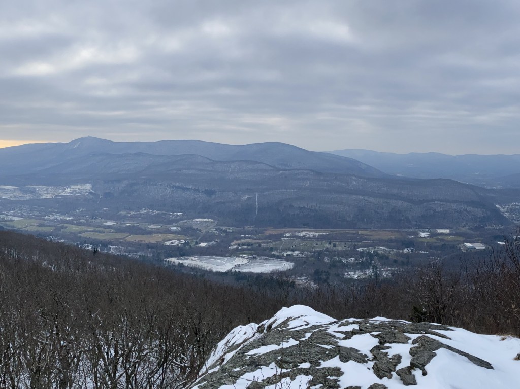
General info: Mount Williams technically falls just short of the 200-foot prominence cutoff generally used by this project–it has about 190 feet. But at roughly 2,965 feet in overall elevation, it still ranks among the highest summits in Massachusetts and is difficult to dismiss on a technicality. It forms the northernmost peak of the Greylock Massif, the long Taconic ridge dominated by Mount Greylock, and it is also the highest point within the city of North Adams. The mountain lies entirely inside Mount Greylock State Reservation, and the Appalachian Trail crosses directly over the summit, tying it into an extensive network of reservation trails. Hikers can visit Williams on a short out-and-back or include it as part of a longer traverse to Mount Fitch and Mount Greylock to the south.
Geologically, Mount Williams shares the same ancient Taconic-age schist as its higher neighbor, shaped by glaciation into the rounded, rugged summit we see today. And although it is officially a subpeak of Greylock, it feels very much like a distinct mountain. The trail climbs through spruce-hardwood forest to a fine open outlook with views over North Adams and the Northern Hoosac Range of the Berkshires. With its elevation, scenery, and excellent trail access, Mount Williams more than earns its place among the noteworthy peaks of Massachusetts.
Historical background: Mount Williams was named in honor of Colonel Ephraim Williams Jr. (1715–1755), a Newton-born landowner and militia officer who moved to Stockbridge in the 1740s and became a prominent figure on Massachusetts’ western frontier. He was commissioned captain during King George’s War and was put in charge of building and defending Fort Massachusetts, a key wooden stockade on the Hoosac River that guarded the colony’s remote northwest corner within present-day North Adams. Williams later rose to the rank of colonel during the French and Indian War and was killed leading his regiment during the “Bloody Morning Scout” at the Battle of Lake George on September 8, 1755. In his will, written shortly before that campaign, he left a large estate to endow a free school in the frontier township of West Hoosac, on the conditions that the town take his name—Williamstown—and that the school be built there. The school opened in 1791 and was later elevated to Williams College in 1793. For his prominent role in the French and Indian War, some early-20th-century local historians even suggested that a monument to Williams belonged on the summit of Mount Williams, the northern buttress of the Greylock range, underscoring how closely the peak was associated with his memory. Fortunately, this never occurred. From 1937-1944, then again from 1954-1958, the North Adams Ski Club maintained a ski area on the Paul Bernard’s Farm on the lower slopes of Mount Williams. Most of this land is wooded now but you can traverse it along the Bernard Farm Trail.
Recommended ascent routes: A DCR trail map can be found here. There are three routes to approach the summit:
Bernard Farm Trail to Appalachian Trail: Find this route on AllTrails here. This is a great short route if you just want a fairly quick day hike to reach Mount Williams, and it’s the one I happened to take. Lots of parking at the Notch Road Trailhead. It’s 5 miles out and back with roughly 1,561 feet of elevation gain. Parts of the Bernard Farm trail are straight and easy going and appear to be (as the name would suggest) part of an old farm road. In other places it runs up steep ground through a series of little switchbacks. I found the half-mile or so just before reaching the AT fairly challenging. Once you hit the Appalachian Trail, it’s easy going to the summit where there is a prominent sign. There is wreckage along this route of a small Piper plane, rather sad. The terrain was apparently too rugged and remote to remove what’s left of the fuselage.
Mount Williams Trail: Find this route on AllTrails here. About 6 miles and 2,400 feet of elevation gain. I’d like to do this route at some point. Essentially just the AT all the way from the AT Pattison Road lot. I did part of this on my way to Mount Prospect and it was beautiful, though steep. Where the AT breaks away from the Mount Prospect Trail, there’s a great overlook to the west.
Appalachian Trail from the South: Of course, through-hikers headed north from Greylock along the Appalachian Trail will eventually come across the summit of Mount Williams. As mentioned, it’s about 2.5 miles from the Greylock summit.
Nearby Listed Peaks: The Greylock Massif consists of a number of peaks, some of them prominent enough to be considered independent. Several nearby are on the Mass Public Peaks list including Greylock itself, Saddle Ball Mountain, Stony Ledge, Ragged Mountain, Mount Prospect, and Rounds Rock. Those interested in a longer hike could include any of these with Mount Williams.
Back to Massachusetts 50 Highest Public Peaks list
Click on the images to enlarge:


Leave a comment